
Me Hoprê Catejê

Screenshot 2026-02-04 at 13.54.31
Credit: Me Hoprê Catejê
Indigenous-led territorial protection safeguarding one of the largest continuous Cerrado areas on the planet, through community-based monitoring expeditions
ABOUT ME HOPRÊ CATEJÊ
ABOUT ME HOPRÊ CATEJÊ
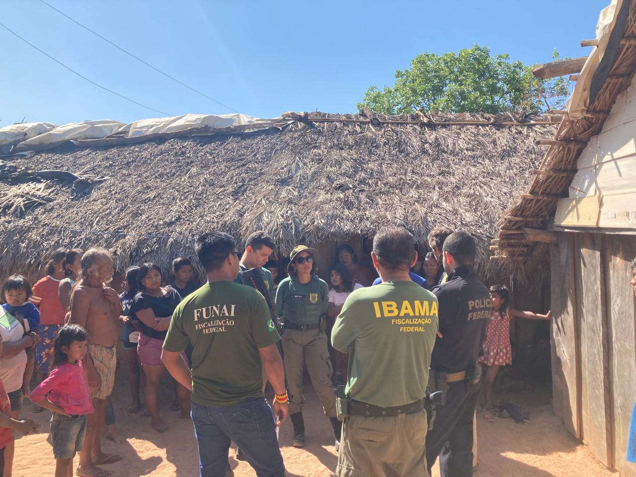
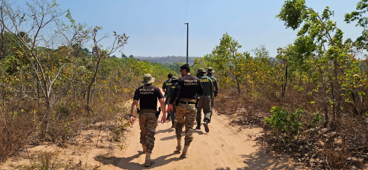
Me Hoprê Catejê—”The Warriors of the Cerrado”—is an Indigenous territorial vigilance group formed by women and men of the Krahô people. Operating with political autonomy while coordinating with government agencies including FUNAI, IBAMA, and the Federal Police, this community-led organization conducts systematic monitoring and protection of the Terra Indígena Krahô through traditional walking expeditions they call “andadas.”

Screenshot 2026-02-04 at 13.53.11
Credit: Me Hoprê Catejê
The Krahô, who call themselves Mehĩ, are immemorial inhabitants of the Cerrado—Brazil’s vast savanna. Their demarcated territory, Terra Indígena Krahô, spans approximately 303,000 hectares in northern Tocantins state, representing one of the largest continuous areas of preserved Cerrado on the planet. Home to approximately 4,500 people living in 42 circular villages, each centered around a communal patio where daily life unfolds.

Screenshot 2026-02-04 at 13.53.58
Credit: Me Hoprê Catejê
The Cerrado, often called “the cradle of waters,” gives rise to major Brazilian watersheds including the Amazon and São Francisco basins. Despite its critical ecological importance as a global biodiversity hotspot, less than fifty percent of the original biome remains. The Krahô have maintained their territory in remarkable preservation—their waters clean, their traditional hunting and agricultural practices intact—while neighboring agribusiness operations have transformed the surrounding landscape into cattle ranches and monoculture plantations.
This expansion has brought mounting pressures to the territory’s borders: illegal cattle grazing, deforestation, water contamination from pesticides and farming runoff, theft of valuable timber species like aroeira, jatobá, and ipê, wildlife trafficking—particularly of macaws whose populations have noticeably declined—and intentional fires set to open land for pasture. The territorial demarcation itself followed a massacre in which Krahô ancestors were killed by regional ranchers.
")
WhatsApp Image 2026-01-05 at 15.32.13 (4)
Credit: Me Hoprê Catejê
Origins and development
The Krahô organized their first territorial protection efforts in 2012, initially establishing a checkpoint at the main entrance to the Indigenous territory. During the COVID-19 pandemic, this station proved invaluable for disinfecting vehicles and supplies entering the area, significantly delaying the virus’s arrival. After pandemic support ended, the checkpoint became intermittent, but the warriors’ commitment to territorial protection never wavered.
In September 2024, the group conducted a major ten-day expedition in the southern quadrant of the territory, documenting numerous problems along the borders including conflicts with a rancher who had illegally planted brachiaria grass—a highly invasive non-native species that destroys Cerrado vegetation—and introduced cattle onto Krahô land. This experience crystallized the need to formalize their monitoring activities and seek partnerships beyond government agencies, whose support can be unpredictable given political changes.

Screenshot 2026-02-04 at 13.52.38
Credit: Me Hoprê Catejê
The group now comprises 20 Indigenous environmental agents, drawing members from villages across the territory. Their activities follow traditional knowledge and the Krahô seasonal calendar, dividing the territory into four quadrants—West, East, North, and South—that are monitored according to weather patterns and traditional resource management practices. During dry season months, they traverse the eastern regions with extensive “dry line” borders vulnerable to invasion; during rainy season, they conduct river expeditions along the northern fluvial boundaries.
WhatsApp Image 2026-02-04 at 16.38.36
Crucial coordination with governmental agencies - FUNAI, IBAMA and the Federal Police | Credit: Me Hoprê Catejê
WhatsApp Image 2026-02-04 at 16.38.45
Crucial coordination with governmental agencies - FUNAI, IBAMA and the Federal Police | Credit: Me Hoprê Catejê
WhatsApp Image 2026-02-04 at 16.38.54
Crucial coordination with governmental agencies - FUNAI, IBAMA and the Federal Police | Credit: Me Hoprê Catejê
WhatsApp Image 2026-02-04 at 16.38.28
Crucial coordination with governmental agencies - FUNAI, IBAMA and the Federal Police | Credit: Me Hoprê Catejê
WhatsApp Image 2026-02-04 at 16.57.37
Crucial coordination with governmental agencies - FUNAI, IBAMA and the Federal Police | Credit: Me Hoprê Catejê
WhatsApp Image 2026-02-04 at 16.57.31
Crucial coordination with governmental agencies - FUNAI, IBAMA and the Federal Police | Credit: Me Hoprê Catejê
OUR PARTNERSHIP
OUR PARTNERSHIP
Walking the Territory: Supporting Indigenous-Led Monitoring
Our partnership with Me Hoprê Catejê began in 2025, responding to the group’s clearly articulated vision for protecting their territory through their own methods and knowledge systems. The Krahô developed their monitoring approach based on a fundamental insight: the most effective way to understand what is happening in their vast territory is by walking it. Despite the enormous distances involved, it is with their feet on the ground that they perceive where the greatest threats lie—not only to their lives but to the life of the Cerrado itself.
The Krahô can identify every river, every tree, animal tracks, and the subtle signs of invaders—a trail left by trespassers, or the absence of a bird’s song indicating it has been stolen from the territory. Their approach is non-confrontational, seeking dialogue with invaders about respecting territorial boundaries, while coordinating with federal agencies when formal intervention becomes necessary.

WhatsApp Image 2026-01-08 at 17.05.44
Credit: Me Hoprê Catejê
Azimuth World Foundation provides support that complements FUNAI’s assistance—which covers some logistics but cannot guarantee all the necessary fuel and food, and does not fund technical equipment essential for effective monitoring. Our funding enables the acquisition of crucial equipment including drones for aerial documentation, long-range radios for communication during expeditions, GPS devices, and the rental of additional vehicles that significantly expand the group’s operational capacity. Building some independence from government resources alone has proven vital, providing time, resources, and security to navigate institutional changes.
The partnership works in coordination with AmazoniAlerta, a Brazilian organization that provides technical accompaniment and handles the legal follow-up on documented violations. This represents AmazoniAlerta’s first partnership with an Indigenous territorial monitoring group outside the Amazon region, recognizing that protecting the Cerrado—whose waters feed the Amazon—requires an integrated approach to territorial defense across biomes.

Screenshot 2026-02-04 at 13.54.09
Credit: Me Hoprê Catejê
Building Community Cohesion Through the Andadas
The monitoring expeditions have generated impact far beyond territorial protection. Each andada brings warriors from different villages together, and as they visit communities along their routes, they hold village meetings that strengthen connections across the territory. These gatherings have become crucial spaces for discussing contemporary challenges, including the preservation of traditional culture and language among youth.
By including three to four members from each village visited, the expeditions have created a profound sense of collective ownership. The project belongs to all Krahô people, not just to one organization—a transformation made possible by extra resources that allow the group to complement and diversify the more rigid assistance provided by government agencies.
")
WhatsApp Image 2026-01-05 at 15.33.21 (1)
Credit: Me Hoprê Catejê
The warriors’ regular presence in different regions serves as an effective deterrent against invasions, demonstrating the Krahô’s active occupation of their territory. They have discovered and repositioned FUNAI boundary markers that had been moved by invaders, preventing strategies of illegal land appropriation. They have identified and reported illegal activities in buffer zones, including unauthorized construction of artificial lakes for cattle operations.
Our partnership continues into 2026, supporting an expanded calendar of monitoring expeditions, capacity-building activities, and the ongoing work of documenting and responding to territorial threats.

WhatsApp Image 2026-01-26 at 12.35.37
Credit: Me Hoprê Catejê
IMPACT
IMPACT
Since the partnership began, the monitoring expeditions have produced concrete results for territorial protection while strengthening community organization:
Territorial Documentation and Response
Multiple expeditions have covered all four quadrants of the territory, documenting illegal cattle grazing, signs of illegal mining activity, water contamination in rivers bordering ranches, evidence of wildlife trafficking contributing to the alarming absence of macaws, theft of valuable timber species, and unauthorized land clearing. This evidence will support formal complaints filed through partner organizations and government agencies.
Boundary Marker Recovery
The group discovered and repositioned FUNAI territorial markers that invaders had moved, directly preventing strategies of gradual land theft.
")
WhatsApp Image 2026-01-05 at 15.32.12 (7)
Credit: Me Hoprê Catejê
Deterrence Through Presence
Regular monitoring expeditions across all territorial sectors demonstrate active Indigenous occupation, deterring potential invaders who might otherwise take advantage of the territory’s remoteness.
Equipment and Capacity Building
Use of drone technology, communication equipment, and additional vehicles has dramatically enhanced monitoring effectiveness. Capacity-building sessions have generated enthusiasm among participants and improved documentation protocols.
Inter-Village Strengthening
The expeditions have revitalized connections between villages, creating spaces for community dialogue on pressing issues and reinforcing the sense that territorial protection is a collective responsibility of all Krahô people.

Screenshot 2026-02-04 at 13.52.56
Credit: Me Hoprê Catejê
Institutional Resilience
Independent resources have allowed the group to maintain continuity through government transitions.
Environmental Monitoring
Detailed observations document concerning ecological changes—the dramatic decline of macaw populations, reduction in fish species, contamination of rivers previously clean for drinking and bathing, and the replacement of native forest with invasive grasses and secondary growth where valuable timber once stood.
The monitoring has also revealed complex internal challenges requiring community-wide attention, such as situations of illegal land leasing. The andadas have created forums where these difficult conversations can occur, guided by traditional leadership and collective decision-making.
UPDATES
UPDATES
View this post on Instagram
View this post on Instagram
Share

Me Hoprê Catejê
Screenshot 2026-02-04 at 13.54.31
Credit: Me Hoprê Catejê
Indigenous-led territorial protection safeguarding one of the largest continuous Cerrado areas on the planet, through community-based monitoring expeditions
ABOUT ME HOPRÊ CATEJÊ
ABOUT ME HOPRÊ CATEJÊ
Me Hoprê Catejê—”The Warriors of the Cerrado”—is an Indigenous territorial vigilance group formed by women and men of the Krahô people. Operating with political autonomy while coordinating with government agencies including FUNAI, IBAMA, and the Federal Police, this community-led organization conducts systematic monitoring and protection of the Terra Indígena Krahô through traditional walking expeditions they call “andadas.”
Screenshot 2026-02-04 at 13.53.11
Credit: Me Hoprê Catejê
The Krahô, who call themselves Mehĩ, are immemorial inhabitants of the Cerrado—Brazil’s vast savanna. Their demarcated territory, Terra Indígena Krahô, spans approximately 303,000 hectares in northern Tocantins state, representing one of the largest continuous areas of preserved Cerrado on the planet. Home to approximately 4,500 people living in 42 circular villages, each centered around a communal patio where daily life unfolds.
Screenshot 2026-02-04 at 13.53.58
Credit: Me Hoprê Catejê
The Cerrado, often called “the cradle of waters,” gives rise to major Brazilian watersheds including the Amazon and São Francisco basins. Despite its critical ecological importance as a global biodiversity hotspot, less than fifty percent of the original biome remains. The Krahô have maintained their territory in remarkable preservation—their waters clean, their traditional hunting and agricultural practices intact—while neighboring agribusiness operations have transformed the surrounding landscape into cattle ranches and monoculture plantations.
This expansion has brought mounting pressures to the territory’s borders: illegal cattle grazing, deforestation, water contamination from pesticides and farming runoff, theft of valuable timber species like aroeira, jatobá, and ipê, wildlife trafficking—particularly of macaws whose populations have noticeably declined—and intentional fires set to open land for pasture. The territorial demarcation itself followed a massacre in which Krahô ancestors were killed by regional ranchers.
WhatsApp Image 2026-01-05 at 15.32.13 (4)
Credit: Me Hoprê Catejê
Origins and development
The Krahô organized their first territorial protection efforts in 2012, initially establishing a checkpoint at the main entrance to the Indigenous territory. During the COVID-19 pandemic, this station proved invaluable for disinfecting vehicles and supplies entering the area, significantly delaying the virus’s arrival. After pandemic support ended, the checkpoint became intermittent, but the warriors’ commitment to territorial protection never wavered.
In September 2024, the group conducted a major ten-day expedition in the southern quadrant of the territory, documenting numerous problems along the borders including conflicts with a rancher who had illegally planted brachiaria grass—a highly invasive non-native species that destroys Cerrado vegetation—and introduced cattle onto Krahô land. This experience crystallized the need to formalize their monitoring activities and seek partnerships beyond government agencies, whose support can be unpredictable given political changes.
Screenshot 2026-02-04 at 13.52.38
Credit: Me Hoprê Catejê
The group now comprises 20 Indigenous environmental agents, drawing members from villages across the territory. Their activities follow traditional knowledge and the Krahô seasonal calendar, dividing the territory into four quadrants—West, East, North, and South—that are monitored according to weather patterns and traditional resource management practices. During dry season months, they traverse the eastern regions with extensive “dry line” borders vulnerable to invasion; during rainy season, they conduct river expeditions along the northern fluvial boundaries.
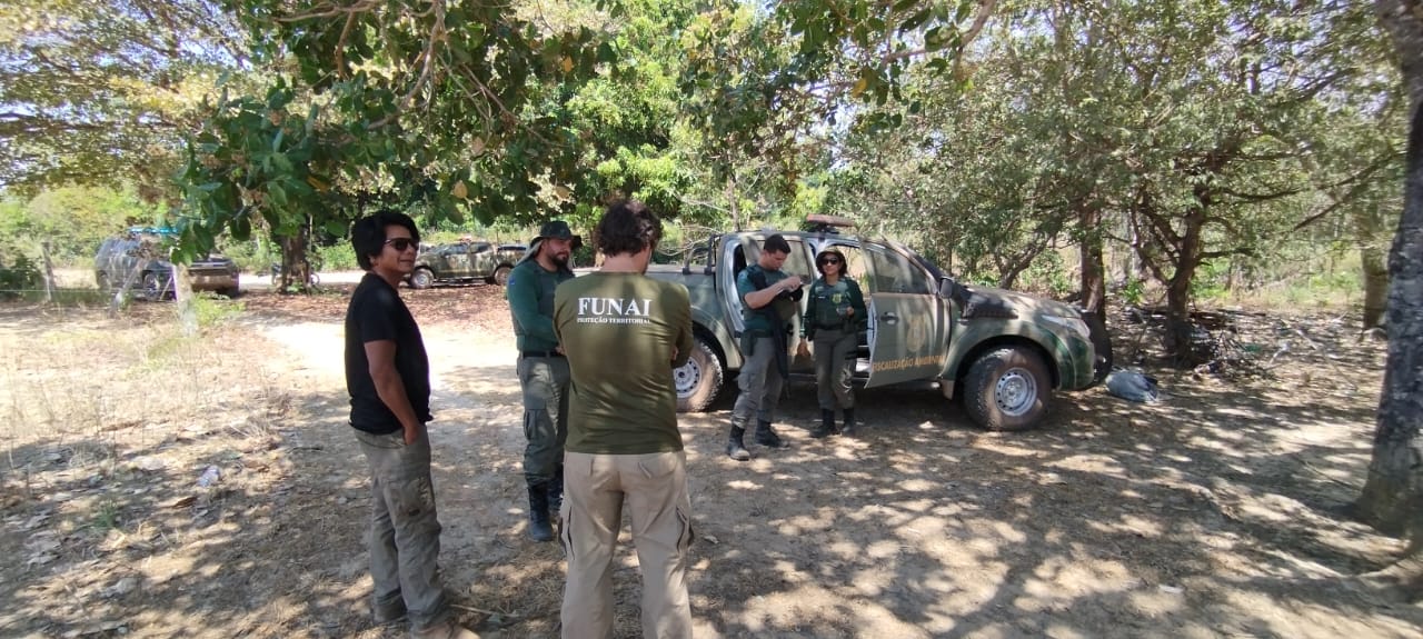
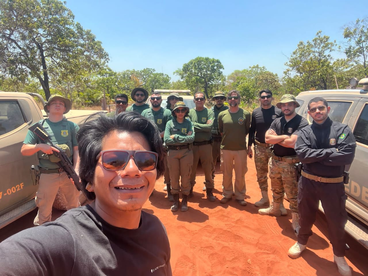
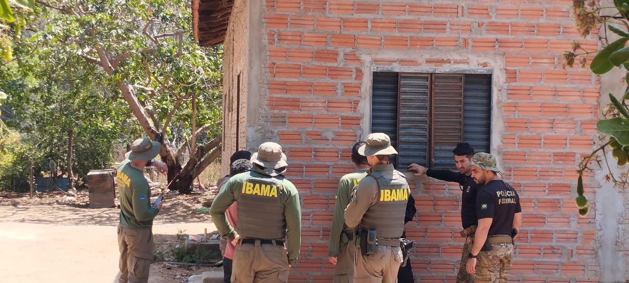
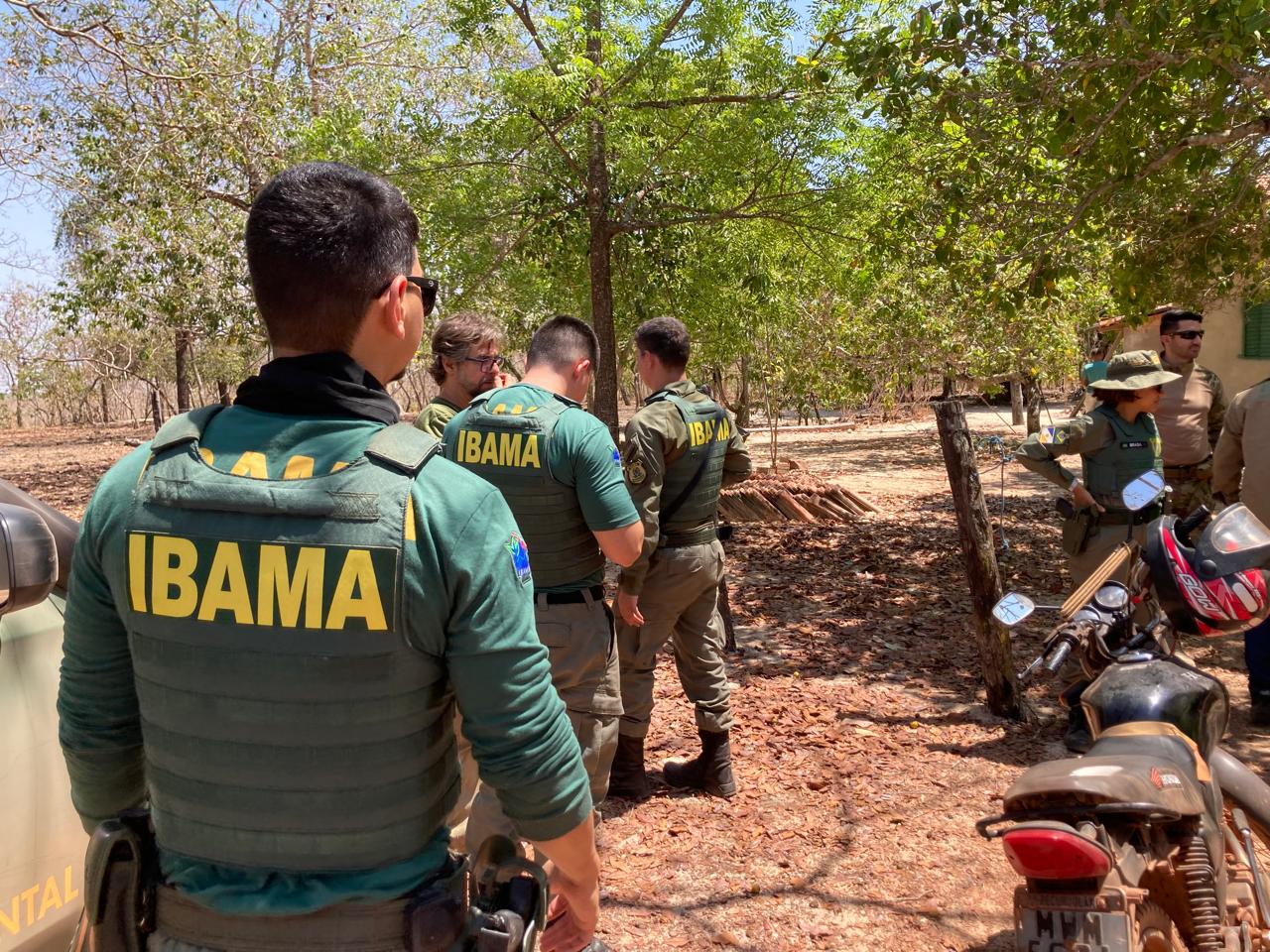
WhatsApp Image 2026-02-04 at 16.38.36
Crucial coordination with governmental agencies - FUNAI, IBAMA and the Federal Police | Credit: Me Hoprê Catejê
WhatsApp Image 2026-02-04 at 16.38.45
Crucial coordination with governmental agencies - FUNAI, IBAMA and the Federal Police | Credit: Me Hoprê Catejê
WhatsApp Image 2026-02-04 at 16.38.54
Crucial coordination with governmental agencies - FUNAI, IBAMA and the Federal Police | Credit: Me Hoprê Catejê
WhatsApp Image 2026-02-04 at 16.38.28
Crucial coordination with governmental agencies - FUNAI, IBAMA and the Federal Police | Credit: Me Hoprê Catejê
WhatsApp Image 2026-02-04 at 16.57.37
Crucial coordination with governmental agencies - FUNAI, IBAMA and the Federal Police | Credit: Me Hoprê Catejê
WhatsApp Image 2026-02-04 at 16.57.31
Crucial coordination with governmental agencies - FUNAI, IBAMA and the Federal Police | Credit: Me Hoprê Catejê
OUR PARTNERSHIP
OUR PARTNERSHIP
Walking the Territory: Supporting Indigenous-Led Monitoring
Our partnership with Me Hoprê Catejê began in 2025, responding to the group’s clearly articulated vision for protecting their territory through their own methods and knowledge systems. The Krahô developed their monitoring approach based on a fundamental insight: the most effective way to understand what is happening in their vast territory is by walking it. Despite the enormous distances involved, it is with their feet on the ground that they perceive where the greatest threats lie—not only to their lives but to the life of the Cerrado itself.
The Krahô can identify every river, every tree, animal tracks, and the subtle signs of invaders—a trail left by trespassers, or the absence of a bird’s song indicating it has been stolen from the territory. Their approach is non-confrontational, seeking dialogue with invaders about respecting territorial boundaries, while coordinating with federal agencies when formal intervention becomes necessary.
WhatsApp Image 2026-01-08 at 17.05.44
Credit: Me Hoprê Catejê
Azimuth World Foundation provides support that complements FUNAI’s assistance—which covers some logistics but cannot guarantee all the necessary fuel and food, and does not fund technical equipment essential for effective monitoring. Our funding enables the acquisition of crucial equipment including drones for aerial documentation, long-range radios for communication during expeditions, GPS devices, and the rental of additional vehicles that significantly expand the group’s operational capacity. Building some independence from government resources alone has proven vital, providing time, resources, and security to navigate institutional changes.
The partnership works in coordination with AmazoniAlerta, a Brazilian organization that provides technical accompaniment and handles the legal follow-up on documented violations. This represents AmazoniAlerta’s first partnership with an Indigenous territorial monitoring group outside the Amazon region, recognizing that protecting the Cerrado—whose waters feed the Amazon—requires an integrated approach to territorial defense across biomes.
Screenshot 2026-02-04 at 13.54.09
Credit: Me Hoprê Catejê
Building Community Cohesion Through the Andadas
The monitoring expeditions have generated impact far beyond territorial protection. Each andada brings warriors from different villages together, and as they visit communities along their routes, they hold village meetings that strengthen connections across the territory. These gatherings have become crucial spaces for discussing contemporary challenges, including the preservation of traditional culture and language among youth.
By including three to four members from each village visited, the expeditions have created a profound sense of collective ownership. The project belongs to all Krahô people, not just to one organization—a transformation made possible by extra resources that allow the group to complement and diversify the more rigid assistance provided by government agencies.
WhatsApp Image 2026-01-05 at 15.33.21 (1)
Credit: Me Hoprê Catejê
The warriors’ regular presence in different regions serves as an effective deterrent against invasions, demonstrating the Krahô’s active occupation of their territory. They have discovered and repositioned FUNAI boundary markers that had been moved by invaders, preventing strategies of illegal land appropriation. They have identified and reported illegal activities in buffer zones, including unauthorized construction of artificial lakes for cattle operations.
Our partnership continues into 2026, supporting an expanded calendar of monitoring expeditions, capacity-building activities, and the ongoing work of documenting and responding to territorial threats.
WhatsApp Image 2026-01-26 at 12.35.37
Credit: Me Hoprê Catejê
IMPACT
IMPACT
Since the partnership began, the monitoring expeditions have produced concrete results for territorial protection while strengthening community organization:
Territorial Documentation and Response
Multiple expeditions have covered all four quadrants of the territory, documenting illegal cattle grazing, signs of illegal mining activity, water contamination in rivers bordering ranches, evidence of wildlife trafficking contributing to the alarming absence of macaws, theft of valuable timber species, and unauthorized land clearing. This evidence will support formal complaints filed through partner organizations and government agencies.
Boundary Marker Recovery
The group discovered and repositioned FUNAI territorial markers that invaders had moved, directly preventing strategies of gradual land theft.
WhatsApp Image 2026-01-05 at 15.32.12 (7)
Credit: Me Hoprê Catejê
Deterrence Through Presence
Regular monitoring expeditions across all territorial sectors demonstrate active Indigenous occupation, deterring potential invaders who might otherwise take advantage of the territory’s remoteness.
Equipment and Capacity Building
Use of drone technology, communication equipment, and additional vehicles has dramatically enhanced monitoring effectiveness. Capacity-building sessions have generated enthusiasm among participants and improved documentation protocols.
Inter-Village Strengthening
The expeditions have revitalized connections between villages, creating spaces for community dialogue on pressing issues and reinforcing the sense that territorial protection is a collective responsibility of all Krahô people.
Screenshot 2026-02-04 at 13.52.56
Credit: Me Hoprê Catejê
Institutional Resilience
Independent resources have allowed the group to maintain continuity through government transitions.
Environmental Monitoring
Detailed observations document concerning ecological changes—the dramatic decline of macaw populations, reduction in fish species, contamination of rivers previously clean for drinking and bathing, and the replacement of native forest with invasive grasses and secondary growth where valuable timber once stood.
The monitoring has also revealed complex internal challenges requiring community-wide attention, such as situations of illegal land leasing. The andadas have created forums where these difficult conversations can occur, guided by traditional leadership and collective decision-making.
UPDATES
UPDATES
View this post on Instagram
View this post on Instagram
Share


